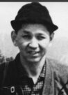
Yotsugi Kawahara
A handmade album with a cardboard cover bears the title, written in India ink, “Photographs of the A-bomb Damage in Hiroshima.” Inside are 23 vivid photos which show the destruction that occurred on August 6, 1945. These images are original prints, left by Yotsugi Kawahara, 川原 四儀 a member of the photography team of the Army Marine Headquarters. Mr. Kawahara died of adrenal cancer in 1972 at the age of 49, probably due to the aftereffects of the radiation released in the A-bomb blast.
His wife, Mineko Kawahara, 84, who lives in Hakushima-cho, Naka Ward, ushered me into their house and showed me the album he had left behind. “My husband told me that he took the photos on orders of the army and that when the war ended, he disposed of the negatives by burning them or burying them in the ground,” she explained. When, where, and how were these photographs taken? As I sought this information, I gradually came to learn the unknown facts behind these valuable images which show the effects of the atomic bombing on the city of Hiroshima.
In 1968, Mr. Kawahara visited City Hall with former members of the photography team and revealed the album to the public. According to a newspaper article which appeared at that time, he said, “The photos exhibited at Peace Memorial Museum and other places are copies of the original prints. One of the members of the photography team probably offered the copies to these places.” Mr. Kawahara said the pictures were taken in the aftermath of the blast. To verify this, he brought the album with the original images.
Mr. Kawahara also said that he hoped to reflect on his memories and add accurate data to accompany the images, but he soon fell ill and then was unable to accomplish this task. Thus, his photos, which have appeared in many collections, bear varying dates and explanations, and are sometimes incorrect. The images, too, have been repeatedly copied and the copies lack clarity.
With Mrs. Kawahara’s help, I tried to determine the facts, using the original prints and Mr. Kawahara’s application for the A-bomb Survivor’s Certificate, which he had made one year before his death.
When the atomic bomb exploded, Mr. Kawahara was “sitting at a desk in the western room of the photography team” at the Army Marine Headquarters, located 4.6 kilometers from the hypocenter in Ujina Kaigan, Minami Ward. He then “became involved in the relief activities and took photos.” In his application, he explained these activities in detail.
Mr. Kawahara left the Army Marine Headquarters by truck and went along the streetcar tracks to Kamiya-cho. He visited the West Drill Ground, the Second General Army Headquarters, the Hiroshima Army Hospital at Motomachi and its branch hospitals at Mitaki and Eba, accompanied by “army medical officers.” This description matches the activities of the War Ministry’s survey team on the damage in Hiroshima on August 9.
On August 8, two days after the Imperial Headquarters received a report which said that “A special bomb has been dropped on Hiroshima,” the Imperial General Headquarters survey team, made up of nine members, was on board a transport aircraft. Among them was Dr. Yoshio Nishina, a physicist. Five army medical officers were also on board, including Major Kiyoshi Yamashina from the Tokyo First Army Hospital. The “confidential reports” by these medical officers still exist. In 1965, Mr. Yamashina donated the original reports to today’s Research Institute for Radiation Medicine and Biology at Hiroshima University.
“August 9, 8:00 a.m. By vehicle for patients, inspected the city to see the damage caused by the air raid (see photographs).” “Route: Marine Headquarters – General Headquarters – Site of Hiroshima Hospital – Mitaki Branch Hospital – Second Hiroshima Hospital – Eba Branch Hospital – Marine Headquarters.” “Army doctor, Yamashina, went ahead to Ninoshima Island.”
Major Yamashina, a pathologist, performed 12 autopsies on Ninoshima Island, where many survivors were taken and then died. Born in Hiroshima, he opened a clinic in Saeki Ward after the war and died in 1983 at the age of 72. When I visited the clinic, succeeded by his eldest son, I saw a picture that showed the horrifying impact of the atomic bombing. It was probably taken on Ninoshima Island.
From this information, it is certain that Mr. Kawahara’s photos were taken on August 9. The pictures were also attached to the report dated August 10, written by the Imperial General Headquarters survey team including Dr. Nishina, in which they concluded that it was an atomic bomb. I confirmed this by checking the original materials donated to Peace Memorial Museum by Seiichi Niizuma, a former army staff officer. There was a different photo which showed the same officers and the vehicle.
The photography team at the Army Marine Headquarters consisted of seven members. Up to the end of the war, it was mainly Mr. Kawahara and Masami Onuka, 83, a resident of Kawamoto-cho, Shimane Prefecture, who took photos, including those of relief stations. Mr. Onuka said that they were ordered to destroy the negatives, along with confidential documents, at a vacant lot on the grounds of the headquarters. However, Mr. Kawahara and others, who had taken and developed the photos, secretly kept some prints. As a result, these photos, which vividly capture the aftermath of the Hiroshima bombing, still exist today.
After the war, Mr. Kawahara opened a photo studio. He died only 19 days after being hospitalized. In his hospital bed, he called to his family and said, “Let me develop one more photo.” These were his last words.
by Masami Nishimoto
(Originally published on August 3, 2005)
Notes:
https://www.hiroshimapeacemedia.jp/?gallery=2011061414105044_ja
https://hpmm-db.jp/list/?cate=photo&search_type=list&keyword=%E5%B7%9D%E5%8E%9F


